Wednesday, April 26, 2017

The End of My Undergraduate Career

Hello Everyone!

Thank you for following along with my on my journey through my Senior year at Bridgewater State University!

I have reached the end of my internship and while I am sad to go I am excited to start my career on Monday for a large utility company!

This internship has been one of the best experiences of my life, I have learned a lot of information about the electric utility field and I have grown as a person, as I have had to work on real-life projects, conduct research and apply my findings to real life scenarios and present at board meetings. All of this and more has prepped me for the career that I will be starting come Monday.

I want to thank everyone who has followed me on this journey, the wonderful people at NAED and my professor and GIS advisor, Dr. Darcy Boellstorff at BSU. Without all of you I wouldn't be where I am today! Thank you, Thank you, Thank you!

If you're reading this and are an undergraduate considering taking an internship, do it! You won't regret it! I really underestimated just how important an internship is to your work and helping you to move forward in your life and career, I will be forever grateful for this opportunity that I have had working with NAED!

Here is the research poster that I presented at the BSU Research & Arts Symposium on Monday:


Thank you again for reading!
Take Care & God Bless,
Eva Cante
BSU Geography Dept '17

Wednesday, April 19, 2017

Prepping for BSU's Symposium

Previous Research I've Presented at the BSU Symposium, 2013
Hello Everybody!

Well the semester is winding down which means Bridgewater State University's Research and Arts Symposium is just days away! This year's symposium will take place on Monday, April 24th and I will be presenting a research poster for the Collector application project that I have been working on all semester. I am excited to show the campus community what I have been able to accomplish with Collector!

In other news, the inspectors are continuing their inspections of the pad mount transformers using Collector and I have been updating the Map Book for the line crew. My work is winding down as I finish my internship next week. I have had a wonderful experience and without it I don't think I would be able to be heading where I'm going after my internship ends. I am excited for the opportunity that awaits me!

Wednesday, April 12, 2017

AAG & Presentation

Hello Everyone!

So as you may have read from my last blog post, last week I had the opportunity to attend the annual meeting of the American Association of Geographers (AAG) in Boston! Unfortunately, I was sick last week so I was only able to attend on the Friday but I'm very glad that I was able to attend one day out of the five day conference!

Brittney and I at the conference
It was quite the experience! The conference was spread out between the Hynes Convention Center, the Copley Marriott hotel and the Sheraton hotel so there was a lot going on! I went with my friend Brittney and her dad and we were able to attend 2 presentations. The first talk that we went to was given by climate scientist, James Hansen. It was really interesting to hear him talk about how the future generation can battle climate change and help to make changes to reduce our carbon footprint and global warming. I had been really interested in hearing him speak because I had written about him in a paper for my Climatology course at Bridgewater a couple years back. He was awarded the "Honorary Geographer" title by the AAG.

We also attended a talk on the extinction of animals. It was a panel presentation so there were two professors speaking and one graduate student. One professor was from France and he spoke about the extinction of animals and zoos, the other professor was from SUNY and she spoke about the extinction of Corals. The graduate student spoke about a research project that she was in the middle of completing about fish in the Rocky Mountains and how some species of trout are losing their "pure genetics" because they are breeding with different fish species. She talked about how they are using some type of piscicide to kill off the invasive fish species. I personally did not agree with this as they are poisoning the fish and potentially contaminating the water with chemicals that could be harmful to humans or other species of animals.

 
Overall, I was definitely glad that I was able to attend the conference. Definitely bummed that I wasn't feeling well enough to attend more of the conference. Hopefully it will be in Boston again and I'll be able to go or maybe I'll be able to travel to the conference elsewhere another time.

 
In other news...today I was invited to speak to the GIS II class at BSU on how far I've come from learning GIS in the classroom to applying it in the real world at my internship. It was an inspirational and motivational talk of sorts to get the students to consider applying for internships in a field that they want to pursue a career. I will be forever grateful for my time here at the North Attleboro Electric Department and I will miss my coworkers when I leave April 28th to start my new adventure elsewhere.


I hope that everyone has a happy & healthy week!

Wednesday, April 5, 2017

Collector Training!

Hello Everyone!
Me training one of the inspectors
I know that I said I would write about the AAG Conference this week but I will hold off until next week to write about that as I have not attended yet this week...I will be attending on Friday and Saturday!

What I would like to write about this week is that I have trained the 3 person crew who will be conducting the pad mount transformer inspections!

Last Thursday, my manager Heather and I sat with the 3 person crew and their foreman and manager to explain to them what the Collector application is, why we're using it and how to use it. I passed out my 60+ page reference guide for the crew to keep on them so that they can refer to it whenever they have questions or run into an issue before coming to Heather or I. We went on a little field trip (the weather was beautiful last Thursday so it was the perfect day for training) to the transformer outside of the Electric Department offices and to the transformers across the street at the Substation. The crew picked up the workflow for the inspection very easily and were comfortable with the application after doing one inspection each!

Operations Dashboard workflow
Since their training, the crew has been assigned the task of completing as many inspections as they can. So far, they have completed 6 inspections (not including the two from training). I have set up a view in Operations Dashboard so that Heather and I can keep track of the inspections as they happen. We are going to be releasing the Operations Dashboard view shortly to the other managers in the office as well as to the line crew Foreman.

Luckily, there has only been a couple of minor glitches associated with the application since the inspectors have started using it. One glitch being that while I was making edits to the map online while creating the Operations Dashboard view, the crew was unable to access the map. Once they came into the office and I refreshed their devices everything was good to go. Another glitch that they have run into is that the transformer icon doesn't change its color from red to green unless the "Inspected" attribute is changed from "No" to "Yes" however this is not under the inspection report. The change must be done outside of the inspection report on the Transformer layer itself where the photos of the transformer can also be taken. I'm sure after a few more inspections they will fully get used to using the application.

My abstract for the BSU Undergraduate Research Symposium has been submitted and I will be presenting this Collector research project at the Symposium on the 24th! Now that I have mostly completed the project I can start putting together my research poster!

I hope you all have a wonderful week and I'll let you know how the AAG went in next week's blog post!

Wednesday, March 29, 2017

Life Updates

Hi All!

This week has been extremely stressful so I honestly have not been in the office much. My mom fell down the stairs at her work last Wednesday morning and broke both of her ankles so I had been at her home taking care of her until she was admitted to the hospital in Boston last Friday. She has had surgery to repair her left ankle and is doing well considering what happened but she will not be able to bear any weight on her left ankle for 3 months. This has been and certainly will continue to be a learning curve but whatever God brings you to, he brings you through! She has a long road to recovery ahead of her but we're hoping and praying for the best, she will be entering a short-term rehabilitation facility for a week or so before moving back home with my dad and my brother.


In GIS news: I am still working on the Transformer Pad Mount Inspection project, I will be going out with the three person crew and my manager tomorrow to train them on how to use the application and to start collecting data. I'm so glad that we are moving forward with this! I will also be submitting my abstract for the conferences very soon as they are due on Monday, April 3rd...I just need to get the go ahead to move forward with submission.

I am also researching and creating documentation for the new GPS receiver that NAED will be receiving shortly.

There is a lot more going on...including my search for a full-time permanent job position but that is all I will say at the moment! I just wish for luck in my future endeavors whatever they may be! Next week I will be attending the AAG conference at the Hynes Convention Center in Boston with my friend Brittney from BSU who is actually giving a poster presentation at the conference. My blog post next week will focus on the conference! Until then, take care!

Wednesday, March 22, 2017

Forms Galore

Hello All!

I am back from my honeymoon! We just spent a long weekend down the Cape in Chatham. It was fun! Very quiet since most of the shops down there were closed for the season but we still had a good time! The food at our bed & breakfast was delicious...I highly recommend the Chatham Wine Bar & Restaurant at the Chatham Inn at 359 Main. That is where we stayed and ate! There is also a fun candy shop just down the street, the Candy Manor that makes delicious chocolate covered cranberries!! I could eat them for days (:


Anyways, before I ventured off on my honeymoon I was learning the ProntoForm system that NAED uses for various forms. Once I figured out my way around the site I created test forms that will hopefully get approved to be created for real use.

I'm still working on the Transformer Pad Inspections project, will hopefully be training the linecrew either this week or next week, we're just tying up some loose ends with the project such as getting the Collector application downloaded on the line crew IPads. I will update on more next week.

Enjoy the week!

Wednesday, March 15, 2017

Wedding, Abstract Writing & More!

Hello Everyone!!

Welcome back from Spring Break!! Today marks 11 days since I married the love of my life! The day was beautiful but freezing cold!! The wind chill made the temperatures feel like they were below zero!! But all went well, everyone had a great time! I've heard so many compliments on the food and the cake, which is great because I didn't get to eat anything except the stuffing!! Now I've just got to go on my honeymoon this weekend and finish my college career on a high note!

I am meeting with the operations manager and the men who will be conducting the transformer pad inspections next week on the 22nd so hopefully we can finish this project completely!! My abstract for both the Bridgewater State University Undergraduate Research Symposium and the NEARC conference are due on the same day, April 3rd. I have been working on my abstract for that which is hard to do since my project isn't finished yet! The critical portions of my research project are done, since the research, development and configuration aspects are done with the project, but the implementation of the application has yet to start so I can't reflect on successes or failures in my abstract. I am assuming that all will go well with the application but you never know if there are any glitches or whatnot! This process has definitely taught me patience. I am one who dedicates my time to one or two tasks and completes them in full before moving on to the next, this process has had me work on numerous tasks while waiting for the inspection process to start with the primary task that I was assigned for this semester. Hopefully this project will be fully completed before I need to present my results at the symposium on April 24th...we shall see!

I have also been spending my time working on a map book that was requested by one of the Engineers here and I have been working with my manager Heather on updating the Fiber Map for another project manager. I still have yet to learn any more about fiber but hopefully will learn that soon too.

For now, please enjoy these pictures from my wedding!

My Wedding Cake! As Dr. James Hayes-Bohanan describes it,
"When a geographer marries"
Myself, my husband Walter, and our good friend Brittney who
is also a graduating senior at BSU majoring in Geography!
 
                                 
Walter and I sharing our first dance to the song
"Rest of My Life" by Bruno Mars
                                  

Wednesday, March 1, 2017

More Adventures with GIS

Hello everyone!!

I can't believe that my wedding is only 3 days away!! I am definitely starting to freak out, I've been engaged for a year and a half now so it's crazy to think how fast the time has passed and now we are here! AHHH!

Anyways, I have been working on other maps and projects for the Electric Department while I wait to train the linemen on how to use the collector application for the pad mount transformer inspections.

One project that I worked on was I had to analyze 5 locations in town where the Electric Department is looking at placing solar farms. I used the spatial analyst extension for ArcGIS Desktop and ran the Area Solar Radiation tool on the DEM for North Attleboro and each desired location. I had done a very similar project for my final project in GEOG 413 last year so I have had experience with using this tool. Since I save all of my notes from my previous classes *in case I ever need to refer to them  again*, I was able to follow my notes from the project I did for class and very easily finish this project for the Electric Department. It is nice to directly apply skills learned in the classroom in the real world!


Another project that I worked on had to deal with the Fiber Cable lines. Now I know almost nothing about Fiber. Going into my internship I knew very little about the electrical system but I am learning more each day! There is one man here who knows everything about fiber, that is his specialty. He will hopefully be sitting down with me sometime soon to teach me about fiber because when I was working on the map for him, much of the information went over my head. I did what I was told and completed it, but what good is a map if only one person can understand it? So I will hopefully be learning about fiber soon.

I shall keep you all updated on GIS and maybe post a wedding picture or two after the big day! Enjoy your upcoming Spring Break, I know I will!

Wednesday, February 22, 2017

Other GIS Endeavors

Hello everyone!

Hope that everyone is having a good week thus far! It's crazy to think that my wedding is only 10 days away now...so close!!

Anyways, I just wanted to update you all on how things are going around here. The transformer pad inspections project is almost completed! I'm just waiting on word to train the inspectors and go out with them on inspections for a few days until they get used to using the IPad and the Collector application for the inspections.

For research purposes, I have looked into other products that offer similar capabilities such as AmigoCloud however I found that it was tricky to use and did not have the functionality to allow a user to only edit pre-existing points nor could I figure out how to get the related table to appear. I consulted with my manager and she said not to worry about looking more into AmigoCloud because it did not appear that it would serve our needs like Collector does.

Since I have been waiting to train the inspectors, I have been working on other GIS tasks and projects in the meantime. I have updated their map that deals with the transformers to reflect the new changes. I have also been working with one of my coworkers, the System Engineer, on editing a map document that will be displayed in his office. I was given a large map that he had printed and was going to hang on the wall. Once my manager and I realized that he was going to hang the map for all to see, we knew that I had to help him since he does not know GIS. He works with it very sparingly.

 
So I took this map containing all of the information on the town's Overhead and Underground Circuit Distribution (wires, circuits, reclosers, capacitors, switches, poles, manholes) and information about the layout of the town (roads, parcels, wetlands, bodies of water). Coming from a GIS and cartographic stand point, having this much information on one map is A LOT. The map that I was given had symbols that were way too big and had labels that you could not even read. I tried to get rid of some of the items like the wetlands, but my coworker insisted that everything stay. He just wanted it all to be readable. So I went through every single street, recloser, capacitor, manhole, 4x4 manhole, and handhole to re-label each and every one. They were all labeled but the labels were not showing up because of their size and position. I converted all of the labels to annotation and went through each label one by one making sure that you could see it and that it was where it was supposed to be. This definitely was a time consuming process and there may have been an easier way to go about things, maybe a python script? But I still am not comfortable with using arcpy mapping as I am afraid I will somehow mess the whole system up! But going through each label one by one needed a lot of patience and ended up being somewhat soothing. I remember when I first took a GIS course, I did not have any patience and I despised the program. However after much hard work, dedication, and learning that I had a knack for perfection, geographical analysis, and mapping, I discovered that I found my niche.

In the end, what I created from the map that I was given was a large map containing all of the information that my coworker requested all at a readable scale and I added the necessary map elements such as the tile, legend, north arrow, scale bar, and data credits. I added in a NAED logo for good measure too.

My coworker just printed the map to hang on his wall and for some reason it looks like one of the reclosers and one of the capacitors were selected and the map ended up exporting and printing them with a blue dot in the middle. Strange as I have never seen that before! But since it's such a minor detail he still hung the map on the wall (I did make sure that there were no more mistakes before exporting it to pdf for a final time).

 
It's always nice to change things up for a while and get back to the basics of GIS, which is cartography. I had a nice few days of just focused work on the map. Now I'll be on to the next project...making solar maps! I'll keep you updated.

Wednesday, February 15, 2017

Substation Tour & Python Scripting

Hope everyone is having a good week!


Photo of a Substation (not the NAED Substation)
I was able to take a tour of the Substation! I certainly learned a lot of new information and was able to see first hand where the towns electrical supply comes from. Of course I did not see where the electricity is generated because that power comes from many miles away at a power plant. What I was able to see was how the Electric Department gets their electricity from the power lines running across the transmission towers that you commonly see along highways or fields. I was also able to see how the voltage gets stepped down to be transported locally and how everything is controlled. It is quite an involved process! I also got to see inside of a pole mounted transformer, and see how  the transformers are repaired and tested. There is a lot of work that has to be done to get the electricity to your home everyday. It is a lot more involved then I'm sure anyone has imagined. We take our electricity for granted, we don't realize the complexity and the dedication of hardworking men and women that it takes for us to simply turn on the light switch or stove or any appliance and to have it work. Touring the substation and seeing things first hand really gave me a better understanding of the work that it takes to get ample amounts of electricity to our homes and businesses.

Transmission Towers


In other news, I have been doing lots of Esri training on Python Scripting. I have completed the web courses and received certificates for the, "Basics of Python (for ArcGIS 10)", "Python Scripting for Geoprocessing Workflows", "Python for Everyone", and "Python Scripting for Map Automation".

 I have been working on these courses because while working with the photo attachments in the Collector App, my manager wanted to be able to export all of the photos into a folder and rename them based on the transformer that they belong to. Seems simple enough right? Well no. With Collector, there is currently no way to rename the photos. When looking at them in ArcGIS Online you have the ability to download the photos one by one, rename name them and then reload them to the map document...that's too much work and tedious. So I found through ESRI that there is a way to batch export all of the photos attachments in ArcMap using a python script. I loaded the script as a new tool in a toolbox and ran the script which produced a folder full of the photos! However the photos had the generic "attach1_photo1", "attach401_photo1" name, not descriptive at all!

Through the help of Esri technical support, my manager and I were able to find where in SQL Server the global id and attachment id's for the photos are located. With that information we are able to go into ArcMap, compare the relative global ids from the photos to the global ids of the transformers and rename the photo. We are sure that there has got to be a python script that can do that for us, but at the current moment we have no idea. In the meantime, I went through and manually changed the names of the photos to reflect the transformer it is attached to.

Once we have the Collector app fully up and running we're hoping to sit down with our IT department to see if they know of a way to automate the renaming of the photos. Let's hope that they can, I will keep you updated!

Wednesday, February 8, 2017

Fieldwork Fun!

Hello Everyone!

For my weekly update, I wanted to let everyone know that I have conducted fieldwork for the application!

Example of some of the Inspection Questions
I have been testing out the application and configuring the tables and required questions for the app. What has been tricky is that Collector does not currently have a functionality where you can set fields as required. This has become a bit of an annoyance as there are certain fields in the table that we would like to be required and others that are not. We have tried to combat this by making the "required" fields not allow Nulls, but each time we have tried to do this we get an error message. For now, our workaround for this issue is that I have renamed the field aliases for the required fields so that they say (Req.) at the end. While this renaming will not enforce these fields as required, it will show the inspectors that these are the fields that they need to be most concerned about when doing an inspection. If we see that these edits have not been made, we will send the inspector back out to collect the information.

But I have successfully tested the application in the field! We have decided to use the Collector App in a connected setting (for now...might change later). It really is a fairly straightforward application to use, I have written up a tutorial on how to use the application for Pad Mount Transformer Inspections in both a connected environment and in a disconnected environment. To be sure that we wanted to use the Collector solely in a connected mode, I was sent out to the western parts of town where the cell phone service can be spotty. I had no trouble getting cell service for the IPad but I did have trouble finding Pad Mount Transformers as I had never been to that part of town before. I should have looked at my map before I went out to do fieldwork but I thought that I would just be able to find transformers on the roads that I was sent too...nope. The Pad Mount Transformers were all on side streets in housing developments....I didn't know that before going out. But I had fun exploring.

In total, I field tested about 30 Pad Mount Transformers. While I was out on my own testing the application, I was just visually inspecting the transformer from the outside. However, I was able to go out to the field with one of the inspectors and see first hand how the actual inspection would go. I was able to see inside both a single phase transformer (supplying houses) and a three phase transformer (supplying a business). It was nice to finally be able to see what I have been customizing the application for. The inspector told me that he'll take me into the substation at one point to see what that is like, should be cool!


  The green triangles represent the transformers that I field tested

 
Hopefully I will be able to train the inspectors on how to use the application soon and then we will see how well the application does in their hands!

Wednesday, February 1, 2017

Making "Pretty" Thumbnail Photos & Helpful Websites

Hello again!

So one of the tasks that I have been given is to create a "pretty" thumbnail photo for the map that will appear on ArcGIS Online as well as on the Collector app.
Generic Automatic Thumbnail

 At our organization, our thumbnail photos for our ArcGIS Online maps are the generic, ArcGIS standard map photos that are given to all thumbnails (as can be seen to the right). Since I had been reading up on how thumbnail photos can really convey the message that your map is trying to send before even actually opening the map, Heather and I decided that it was about time we attempted to create a "pretty" thumbnail photo.

Of course with me starting work in a new topic I had some questions on how to get started creating a thumbnail image, I did not know if there was some type of template that I should be following or if I just could create an image of somesort. ESRI's ArcGIS Blog and GeoNet community are two very helpful websites that I have been turning to for help as I venture along with this project. For any question that I have, or any tricky situation that I encounter, I turn to either one of those websites or I turn to gis.stackexchange.com where I can search through hundreds of previously answered(and some unanswered) questions to see if I am able to find a solution. Almost every question I have had thus far, someone else has had this question too and posted it to one of the websites for responses and discussion. I highly recommend using these websites for help and of course I recommend taking a look at the documentation that ESRI provides for each application/tool/etc. My last resort is calling customer service, because a lot of what I have been working on is completely brand new to me, I cannot explain to myself what is going on, let alone trying to explain it over the phone to somebody else. 99% of the time, one of the websites I mentioned can get me out of any ArcGIS jam that I have.

That being said, I found a helpful blog post on ESRI's ArcGIS Blog entitled, "Put Your Best Thumbnail Forward". The author of the post discussed the advantages to having a customized thumbnail for each map in your organization, and explained that for quality purposes, the thumbnail could only be 200 pixels x 133 pixels and in either PNG, JPEG, or GIF format. It appears as though most people who create appealing thumbnail photos are skilled in using graphics editors such as Photoshop. I have no recent experience in Photoshop so that option was out of the equation...I think that the last time I used Photoshop was in my 6th grade Computer Science class...which was a good 10+ years ago. I have experience in editing photos in Paint...which did not seem to work for me, until I remembered that PowerPoint could probably do the trick!

With Powerpoint, I was able to make the size of the slide equal to the 200 pixels x 133 pixels that are needed for the thumbnail photo, by converting the pixel size to inches. While I am not a graphic designer by any sort, I was able to make a decent photo containing the Pad Mount Transformer map, the North Attleboro Electric Department logo and an explanation of what the map contains. It may get tweaked as the project moves on, but for now, here is the new thumbnail photo for the Pad Mount Transformer Inspections map:


New and Improved Thumbnail

Wednesday, January 25, 2017

Making Progress

Hope everyone is doing well!

We have gotten quite a bit done on this project! My manager, Heather and I, along with another manager at the electric department and the people who will be conducting the inspections have created a database schema for the inspection application to work. What is a schema you ask? Well a schema is just a fancy word for an outline or a model of how something will look. In this case, the schema is an outline for how the inspection table will look, ie. which order the questions will be in, which fields are required which are not, etc.

Since we have the schema set, Heather and I have been testing how the Collector application works with our data. We have created a database in ArcGIS and have configured it with our data so that we are able to take our data offline. We have successfully published our map as a feature service to our server, so that we can securely access it through ArcGIS online, after having complications figuring out why the database would not register on the server. Once in ArcGIS online we have configured the pop-ups and settings so that the essentials will be available on the Collector app. Once the map was enabled for offline editing and shared with the group, I was able to test how Collector works on our IPad. It worked!

While all seemed well and good, we did run into a few problems. When setting up the database and map service, we had decided that we wanted our maps to be versioned. This means that while there is some default map, multiple people can work on other "versions" of the map without the changes being reflected on the default map. The default map only reflects the changes once it has gone through a reconciling process and a posting process. Basically, versioning is done so that edits are not made in error and it is a way to keep track of what data is getting updated and when. I had never worked with versioning before, nor had I ever worked with ArcServer so all of this was brand new to me. Because of this, I ran into errors while trying to download the map onto the IPad when using Collector, I was not supposed to check off a box when I registered the feature class as versioned. So I had to stop the service, unregister the data as versioned and then re-register it, while remembering not to check off the box.

Once we were able to fix that glitch, the edits we made on Collector were showing that they were synching to the server but we could not find those edits anywhere! It seems as though every time we managed to take a step forward, we had to take 5 steps back. Heather and I ended up talking on the phone to an ESRI rep who walked us through reconciling and posting our versioned data. We contacted the rep again the following day to help us enable photo attachments on our database.

This certainly is a learning experience for me! But I am happy to be doing it!

Wednesday, January 18, 2017

Full-Time Internship & Undergraduate Research!

Hi Everyone!

I'm sorry I did not post anything last semester! I was insanely busy last semester...want to know how busy?? I was taking 18 credits at school, while interning part-time at the North Attleboro Electric Department, working part-time at a local consignment shop, maintaining BSU's EarthView blog learning how to live on my own in my very first apartment, raising a 1-month old kitten AND planning my upcoming wedding (which is now 44 days away....eeek!!). How I ended up with a 4.0 GPA for the semester is all attributed to the fact that hard work pays off and that I find myself doing my best when I am stressed out...odd, but it works!

Anyways...the electric department decided to keep me on as their intern for the spring semester! I am beyond excited! I will be here full-time for the semester and will also be conducting undergraduate research with them! Because of these two wonderful opportunities, I only need two additional classes to graduate so I will be taking two online classes this semester and will be graduating May 13th...yippee! Married and a College graduate all within a couple months of each other, busy, busy!


Pad Mount Transformer
For my undergraduate research here, I will be helping the GIS manager to develop and use the Collector App by ESRI to conduct visual maintenance inspections of the Pad Mount Transformers in town. These inspections have never been done so methodically and organized before so this a great asset for the electric department to have. I am excited to see where this project takes the organization and I am excited to see where this internship takes me! Keep checking back as I will be posting every Wednesday through the end of the semester.


Friday, September 23, 2016

GIS Internship!

Hello there!


Image result for great hill trails bridgewater ma
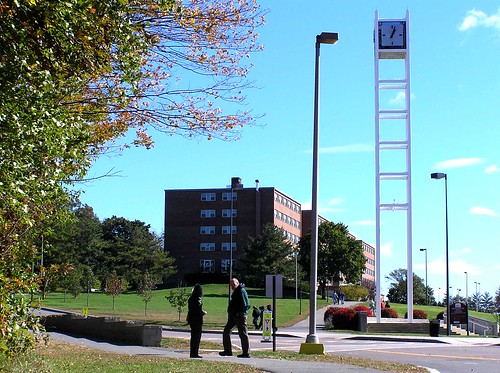
 The former clock tower at BSU
 
It sure has been a while since I last posted something on here...I apologize as I was very busy this summer working and planning my upcoming wedding!

Over this summer though I was able to work with the Director of the Fitness Center at BSU on updating the Great Hill Trail map that he and a former Geography student had created years back. The maps had been updated in 2013 but they needed a little revamp, especially considering that these maps were now going to have a designated spot at the trail head for hikers to take along with them. The map needed additions on two of the trails, objects needed to be removed from the map such as the clock tower, and the map display needed to be set on legal sized paper with an accordion fold. I worked on the map from about late June to late July and am happy to say that the map is on display at the Great Hill Trails trail head at Bridgewater State University and is also online on BSU's Athletic & Recreation's official website!

In other exciting GIS news, I went in for an interview at the North Attleboro Electric Department (on my birthday) for their GIS intern position. I left for Maine a few days later and got a phone call that I got the internship for the Fall semester! I of course took the offer and have been interning here since Sept 7th. My manager is even a graduate of BSU's Geography program. So far, I have been working on a map for a certain area in town making sure that the electrical account numbers match up with the spreadsheet of accounts and vice versa.
Image result for electricity
It is very cool to be able to apply the skills that I have learned in the classroom outside in the real world in a job setting. I am definitely fortunate and blessed that I have been given these great opportunities to use my GIS skills outside of school. I am excited to see where my journey with Geography and GIS will take me in the future!


For now, keep checking back here as I will post updates often as I am getting course credits for my internship and keeping up with this blog is part of what is required of me!


(: Eva

Wednesday, March 30, 2016

Great Blue Hill, Viewshed Analysis on ArcScene

Hello all!

For this week's homework, I was to create a Viewshed Analysis using ArcGIS online and ArcScene. I decided that I would do a Viewshed Analysis of The Great Blue Hill in Milton, Massachusetts. 
Blue Hill
                                   
What is a Viewshed Analysis you ask? Well, suppose you were 5'5" tall and decided to hike up to the top of the 635 foot tall Blue Hill, what would you see if you were to look across the landscape? The Viewshed Analysis tells you just that. On ArcGIS online, you are able to choose any location across the world and place in certain parameters to get the Viewshed Analysis for your selected area. For mine, I chose that the person standing on top of the Great Blue Hill would be 5'5" and that at most, they could see 9 miles out. Below is the Viewshed Analysis for the Great Blue Hill. The orange spots are the areas that you would be able to see. I haven't been up to to the top of the Great Blue Hill in a long time, I'd love to take a hike soon and see how far out I can see! 


Sunday, March 27, 2016

Solar-Wind Village Suitability in Adams, Ma

Happy Easter! 
I hope that you all are enjoying this beautiful Easter Sunday!

The most recent map that I have made for GIS dealt with the potential for a Solar-Wind Village Development in Adams, Massachusetts. I needed to find the locations in town that met the following criteria:

1. The site has to have a slope angle of 20° or less 
2. The slope has to have a southerly aspect (135° to 225°)
3. The wind speed at 30 m has to be above 5 m per second. 

I also needed to specify which locations were "highly suitable", "suitable" or had "limited suitability". The determinations for 

I was given an elevation raster of Adams and from that raster I needed to determine the slope and the aspect of the area. I then needed to obtain the wind speed raster from MassGIS and clip this New England raster down to just Adams.

Once I had found found the aspect of the Adams elevation raster, I used the raster calculator to get a layer of the wind speed and aspect that met criteria #2. I was then able to combine this layer with the slope layer that I had made through the process of determining the slope, reclassifying, and using the raster calculator on that layer. By combining these two layers I had a correct picture of all the criteria met, I just needed to reclassify it again so that the labels would be correct. 

Below is my finished map:

Sunday, March 13, 2016

Nunckatessett Greenway Map Journal

Hi all!

I'm sorry that I haven't been written since mid-February, my life has been very crazy!

Anyway...recently I have been working on the Nunckatessett Greenway Project and the last step of the project was to create a map journal on ArcGIS. 

To view my map journal please click here!

I hope that you enjoy the map journal! This project for class was certainly hard but rewarding! I'm happy to have had the opportunity to work on and improve my GIS skills while working on a real life project. 


Friday, February 19, 2016

Nunckatessett Greenway Parcel Project

This has been one of the more difficult maps that I have ever made on ArcMap. 

There is a group of people from Bridgewater, Massachusetts who have proposed that a Greenway be built through the towns of Bridgewater and West Bridgewater along the Town River. This Greenway would be called the Nunckatessett Greenway and would serve both communities as a walking/biking/running/exploration trail. The goal of the Nunckatessett Greenway project is to promote the natural resources that our around us in the town and bring more businesses and attract more visitors with what the Greenway has to offer. 

This project has been ongoing for the past 10 years and this year the plan is picking up speed with the interest of both town governments. 

For this project, we were asked to find parcels in Bridgewater and West Bridgewater that met criteria for the Greenway and give them a number of 1 if they met that criteria, or 0 if they did not. The criteria were as follows: parcels located within 600 feet of the river, parcels located within 600 feet of a river access point, parcels designated as an area of environmental concern (ex. wetlands, woodlands), parcels that are owned by the state, town, or United States government, and finally parcels with land use codes such as hiking, biking, retail space, residential, recreation...In total we had 7 different criteria that we had to search for in each town's attribute table. Once all of this data was coded, a column titled "Sum" was created so that we could see how many different criteria each parcel met. 

The map below is showing each parcel that either meets, no criteria, 1 criteria, 2, 3, or 4 criteria. It is colored using the gray scale, darker gray meaning that parcel meets more criteria. Along with this map, a table of the parcel ID and the owners of each parcel has been created so that the next step in creating this Greenway can be reached by getting in contact of the parcel owner's and explaining the proposed Nunckatessett Greenway to them. 

To learn more about the Nunckatessett Greenway Project please visit their website here


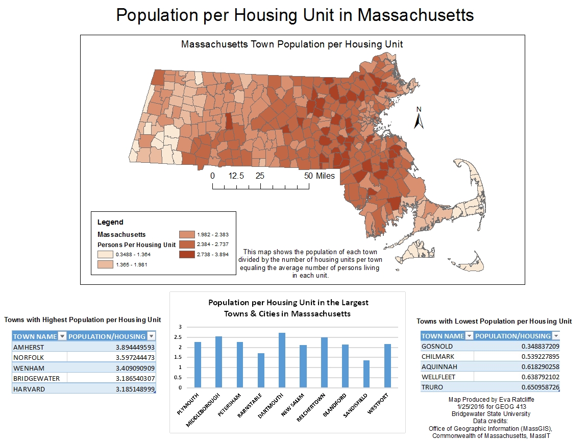
Persons Per Housing Unit in Massachusetts

Below you will find a chloropleth map that I have created showing the Population per Housing Unit in Massachusetts. 

The map shows each town or city colored a shade of red based on the average number of persons living in a housing unit in that city or town. I have also included two tables describing the five towns with the highest amount of persons per housing unit and the five towns with the least amount of persons per housing unit. In addition to the tables, there is also a bar graph showing the persons per housing unit in the 10 largest cities and towns (size based on square miles not population). 

I hope you enjoy the map!