Wednesday, March 30, 2016

Great Blue Hill, Viewshed Analysis on ArcScene

Hello all!

For this week's homework, I was to create a Viewshed Analysis using ArcGIS online and ArcScene. I decided that I would do a Viewshed Analysis of The Great Blue Hill in Milton, Massachusetts. 
Blue Hill
                                   
What is a Viewshed Analysis you ask? Well, suppose you were 5'5" tall and decided to hike up to the top of the 635 foot tall Blue Hill, what would you see if you were to look across the landscape? The Viewshed Analysis tells you just that. On ArcGIS online, you are able to choose any location across the world and place in certain parameters to get the Viewshed Analysis for your selected area. For mine, I chose that the person standing on top of the Great Blue Hill would be 5'5" and that at most, they could see 9 miles out. Below is the Viewshed Analysis for the Great Blue Hill. The orange spots are the areas that you would be able to see. I haven't been up to to the top of the Great Blue Hill in a long time, I'd love to take a hike soon and see how far out I can see! 


Sunday, March 27, 2016

Solar-Wind Village Suitability in Adams, Ma

Happy Easter! 
I hope that you all are enjoying this beautiful Easter Sunday!

The most recent map that I have made for GIS dealt with the potential for a Solar-Wind Village Development in Adams, Massachusetts. I needed to find the locations in town that met the following criteria:

1. The site has to have a slope angle of 20° or less 
2. The slope has to have a southerly aspect (135° to 225°)
3. The wind speed at 30 m has to be above 5 m per second. 

I also needed to specify which locations were "highly suitable", "suitable" or had "limited suitability". The determinations for 

I was given an elevation raster of Adams and from that raster I needed to determine the slope and the aspect of the area. I then needed to obtain the wind speed raster from MassGIS and clip this New England raster down to just Adams.

Once I had found found the aspect of the Adams elevation raster, I used the raster calculator to get a layer of the wind speed and aspect that met criteria #2. I was then able to combine this layer with the slope layer that I had made through the process of determining the slope, reclassifying, and using the raster calculator on that layer. By combining these two layers I had a correct picture of all the criteria met, I just needed to reclassify it again so that the labels would be correct. 

Below is my finished map:

Sunday, March 13, 2016

Nunckatessett Greenway Map Journal

Hi all!

I'm sorry that I haven't been written since mid-February, my life has been very crazy!

Anyway...recently I have been working on the Nunckatessett Greenway Project and the last step of the project was to create a map journal on ArcGIS. 

To view my map journal please click here!

I hope that you enjoy the map journal! This project for class was certainly hard but rewarding! I'm happy to have had the opportunity to work on and improve my GIS skills while working on a real life project. 


Friday, February 19, 2016

Nunckatessett Greenway Parcel Project

This has been one of the more difficult maps that I have ever made on ArcMap. 

There is a group of people from Bridgewater, Massachusetts who have proposed that a Greenway be built through the towns of Bridgewater and West Bridgewater along the Town River. This Greenway would be called the Nunckatessett Greenway and would serve both communities as a walking/biking/running/exploration trail. The goal of the Nunckatessett Greenway project is to promote the natural resources that our around us in the town and bring more businesses and attract more visitors with what the Greenway has to offer. 

This project has been ongoing for the past 10 years and this year the plan is picking up speed with the interest of both town governments. 

For this project, we were asked to find parcels in Bridgewater and West Bridgewater that met criteria for the Greenway and give them a number of 1 if they met that criteria, or 0 if they did not. The criteria were as follows: parcels located within 600 feet of the river, parcels located within 600 feet of a river access point, parcels designated as an area of environmental concern (ex. wetlands, woodlands), parcels that are owned by the state, town, or United States government, and finally parcels with land use codes such as hiking, biking, retail space, residential, recreation...In total we had 7 different criteria that we had to search for in each town's attribute table. Once all of this data was coded, a column titled "Sum" was created so that we could see how many different criteria each parcel met. 

The map below is showing each parcel that either meets, no criteria, 1 criteria, 2, 3, or 4 criteria. It is colored using the gray scale, darker gray meaning that parcel meets more criteria. Along with this map, a table of the parcel ID and the owners of each parcel has been created so that the next step in creating this Greenway can be reached by getting in contact of the parcel owner's and explaining the proposed Nunckatessett Greenway to them. 

To learn more about the Nunckatessett Greenway Project please visit their website here. 


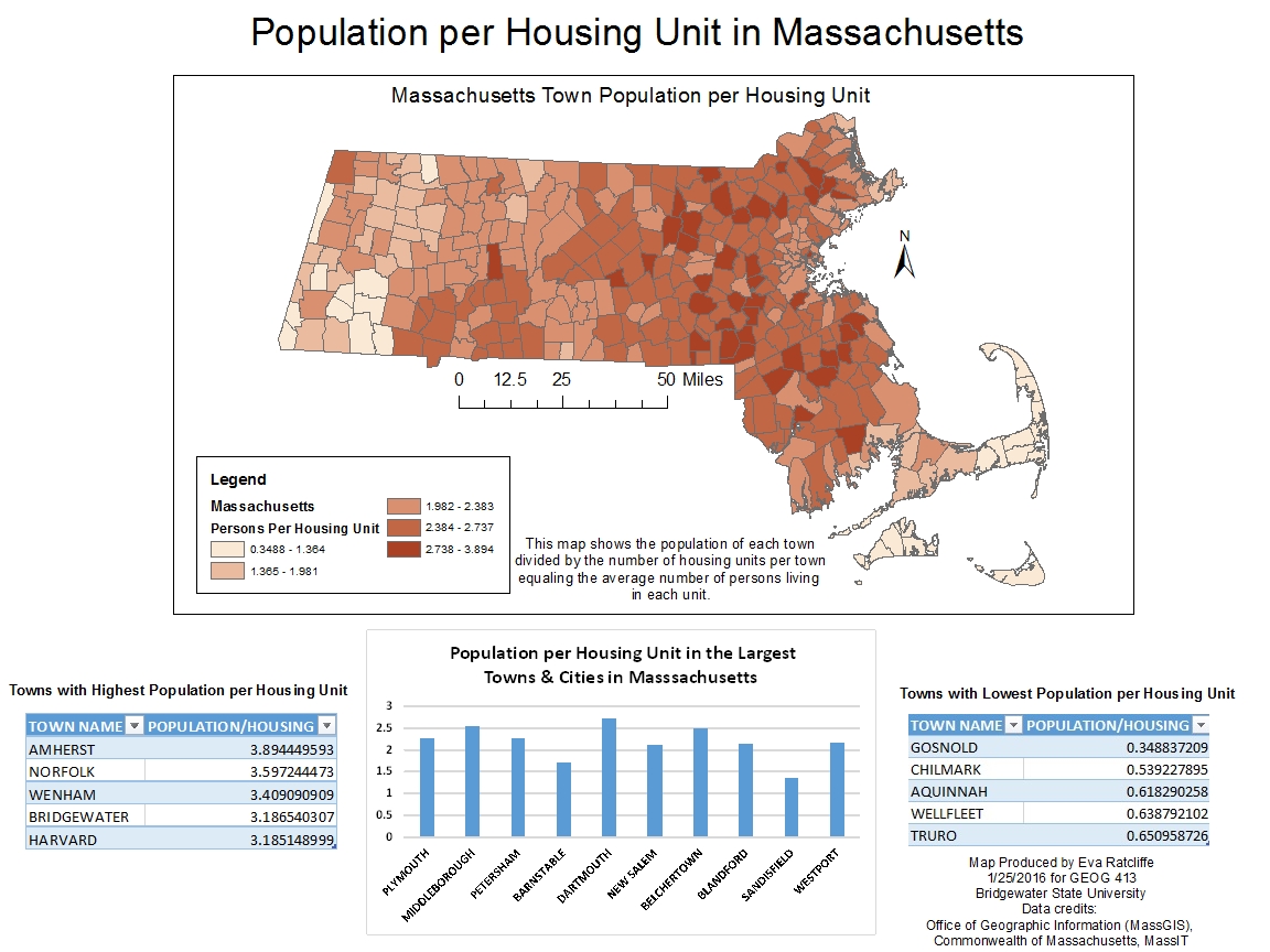
Persons Per Housing Unit in Massachusetts

Below you will find a chloropleth map that I have created showing the Population per Housing Unit in Massachusetts. 

The map shows each town or city colored a shade of red based on the average number of persons living in a housing unit in that city or town. I have also included two tables describing the five towns with the highest amount of persons per housing unit and the five towns with the least amount of persons per housing unit. In addition to the tables, there is also a bar graph showing the persons per housing unit in the 10 largest cities and towns (size based on square miles not population). 

I hope you enjoy the map!


Demographics Map of Bristol, Plymouth & Barnstable Counties

Below you will find a poster that I created for class that describes the demographics of the 10 cities in Bristol, Plymouth, and Barnstable Counties in Massachusetts. The map symbols for the cities are sized based on the population from the 2000 census, while I have also made two bar graphs representing the racial/ethnicity makeup of each city and the housing situation. The data for the map came from ESRI.  I hope that you enjoy the map!


Monday, February 15, 2016

Amusement Parks I've Visited

Below is a map that I have created using ArcGIS online. It displays 10 amusement and water parks that I have visited. 

We didn't have much fun on the
log flume at Canobie!


Of these parks, my favorites have and always will be Story Land in Glen, New Hampshire and Santa's Village in Jefferson, New Hampshire. I started going to both parks when I was 18 months old and went every year until I was 12. While I am definitely too old to enjoy the parks, I cannot wait until I am married (next year!) and start a family of my own so that my future children will enjoy the parks just as I have. 

The most recent park I visited was Canobie Lake Park in Salem, New Hampshire. I was there this past August with my fiancee, my best friend, and her boyfriend.  

My least favorite parks were Hershey Park and Funtown Splashtown USA. I did not enjoy either because I was sick, one from allergies (Hershey Park...I claim to be allergic to Pennsylvania) and the other from motion sickness. Not fun!! But I would give both another chance. 

I would love to get back to Colorado so that I can maybe revisit those amusement parks that I visited in 2006 and add more parks to my map!!