Wednesday, March 1, 2017

More Adventures with GIS

Hello everyone!!

I can't believe that my wedding is only 3 days away!! I am definitely starting to freak out, I've been engaged for a year and a half now so it's crazy to think how fast the time has passed and now we are here! AHHH!

Anyways, I have been working on other maps and projects for the Electric Department while I wait to train the linemen on how to use the collector application for the pad mount transformer inspections.

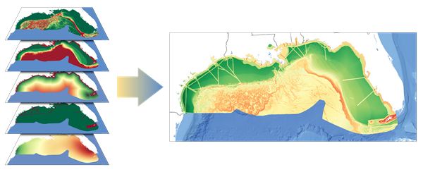
One project that I worked on was I had to analyze 5 locations in town where the Electric Department is looking at placing solar farms. I used the spatial analyst extension for ArcGIS Desktop and ran the Area Solar Radiation tool on the DEM for North Attleboro and each desired location. I had done a very similar project for my final project in GEOG 413 last year so I have had experience with using this tool. Since I save all of my notes from my previous classes *in case I ever need to refer to them  again*, I was able to follow my notes from the project I did for class and very easily finish this project for the Electric Department. It is nice to directly apply skills learned in the classroom in the real world!


Another project that I worked on had to deal with the Fiber Cable lines. Now I know almost nothing about Fiber. Going into my internship I knew very little about the electrical system but I am learning more each day! There is one man here who knows everything about fiber, that is his specialty. He will hopefully be sitting down with me sometime soon to teach me about fiber because when I was working on the map for him, much of the information went over my head. I did what I was told and completed it, but what good is a map if only one person can understand it? So I will hopefully be learning about fiber soon.

I shall keep you all updated on GIS and maybe post a wedding picture or two after the big day! Enjoy your upcoming Spring Break, I know I will!

Wednesday, February 22, 2017

Other GIS Endeavors

Hello everyone!

Hope that everyone is having a good week thus far! It's crazy to think that my wedding is only 10 days away now...so close!!

Anyways, I just wanted to update you all on how things are going around here. The transformer pad inspections project is almost completed! I'm just waiting on word to train the inspectors and go out with them on inspections for a few days until they get used to using the IPad and the Collector application for the inspections.

For research purposes, I have looked into other products that offer similar capabilities such as AmigoCloud however I found that it was tricky to use and did not have the functionality to allow a user to only edit pre-existing points nor could I figure out how to get the related table to appear. I consulted with my manager and she said not to worry about looking more into AmigoCloud because it did not appear that it would serve our needs like Collector does.

Since I have been waiting to train the inspectors, I have been working on other GIS tasks and projects in the meantime. I have updated their map that deals with the transformers to reflect the new changes. I have also been working with one of my coworkers, the System Engineer, on editing a map document that will be displayed in his office. I was given a large map that he had printed and was going to hang on the wall. Once my manager and I realized that he was going to hang the map for all to see, we knew that I had to help him since he does not know GIS. He works with it very sparingly.

 
So I took this map containing all of the information on the town's Overhead and Underground Circuit Distribution (wires, circuits, reclosers, capacitors, switches, poles, manholes) and information about the layout of the town (roads, parcels, wetlands, bodies of water). Coming from a GIS and cartographic stand point, having this much information on one map is A LOT. The map that I was given had symbols that were way too big and had labels that you could not even read. I tried to get rid of some of the items like the wetlands, but my coworker insisted that everything stay. He just wanted it all to be readable. So I went through every single street, recloser, capacitor, manhole, 4x4 manhole, and handhole to re-label each and every one. They were all labeled but the labels were not showing up because of their size and position. I converted all of the labels to annotation and went through each label one by one making sure that you could see it and that it was where it was supposed to be. This definitely was a time consuming process and there may have been an easier way to go about things, maybe a python script? But I still am not comfortable with using arcpy mapping as I am afraid I will somehow mess the whole system up! But going through each label one by one needed a lot of patience and ended up being somewhat soothing. I remember when I first took a GIS course, I did not have any patience and I despised the program. However after much hard work, dedication, and learning that I had a knack for perfection, geographical analysis, and mapping, I discovered that I found my niche.

In the end, what I created from the map that I was given was a large map containing all of the information that my coworker requested all at a readable scale and I added the necessary map elements such as the tile, legend, north arrow, scale bar, and data credits. I added in a NAED logo for good measure too.

My coworker just printed the map to hang on his wall and for some reason it looks like one of the reclosers and one of the capacitors were selected and the map ended up exporting and printing them with a blue dot in the middle. Strange as I have never seen that before! But since it's such a minor detail he still hung the map on the wall (I did make sure that there were no more mistakes before exporting it to pdf for a final time).

 
It's always nice to change things up for a while and get back to the basics of GIS, which is cartography. I had a nice few days of just focused work on the map. Now I'll be on to the next project...making solar maps! I'll keep you updated.

Wednesday, February 15, 2017

Substation Tour & Python Scripting

Hope everyone is having a good week!


Photo of a Substation (not the NAED Substation)
I was able to take a tour of the Substation! I certainly learned a lot of new information and was able to see first hand where the towns electrical supply comes from. Of course I did not see where the electricity is generated because that power comes from many miles away at a power plant. What I was able to see was how the Electric Department gets their electricity from the power lines running across the transmission towers that you commonly see along highways or fields. I was also able to see how the voltage gets stepped down to be transported locally and how everything is controlled. It is quite an involved process! I also got to see inside of a pole mounted transformer, and see how  the transformers are repaired and tested. There is a lot of work that has to be done to get the electricity to your home everyday. It is a lot more involved then I'm sure anyone has imagined. We take our electricity for granted, we don't realize the complexity and the dedication of hardworking men and women that it takes for us to simply turn on the light switch or stove or any appliance and to have it work. Touring the substation and seeing things first hand really gave me a better understanding of the work that it takes to get ample amounts of electricity to our homes and businesses.

Transmission Towers


In other news, I have been doing lots of Esri training on Python Scripting. I have completed the web courses and received certificates for the, "Basics of Python (for ArcGIS 10)", "Python Scripting for Geoprocessing Workflows", "Python for Everyone", and "Python Scripting for Map Automation".

 I have been working on these courses because while working with the photo attachments in the Collector App, my manager wanted to be able to export all of the photos into a folder and rename them based on the transformer that they belong to. Seems simple enough right? Well no. With Collector, there is currently no way to rename the photos. When looking at them in ArcGIS Online you have the ability to download the photos one by one, rename name them and then reload them to the map document...that's too much work and tedious. So I found through ESRI that there is a way to batch export all of the photos attachments in ArcMap using a python script. I loaded the script as a new tool in a toolbox and ran the script which produced a folder full of the photos! However the photos had the generic "attach1_photo1", "attach401_photo1" name, not descriptive at all!

Through the help of Esri technical support, my manager and I were able to find where in SQL Server the global id and attachment id's for the photos are located. With that information we are able to go into ArcMap, compare the relative global ids from the photos to the global ids of the transformers and rename the photo. We are sure that there has got to be a python script that can do that for us, but at the current moment we have no idea. In the meantime, I went through and manually changed the names of the photos to reflect the transformer it is attached to.

Once we have the Collector app fully up and running we're hoping to sit down with our IT department to see if they know of a way to automate the renaming of the photos. Let's hope that they can, I will keep you updated!

Wednesday, February 8, 2017

Fieldwork Fun!

Hello Everyone!

For my weekly update, I wanted to let everyone know that I have conducted fieldwork for the application!

Example of some of the Inspection Questions
I have been testing out the application and configuring the tables and required questions for the app. What has been tricky is that Collector does not currently have a functionality where you can set fields as required. This has become a bit of an annoyance as there are certain fields in the table that we would like to be required and others that are not. We have tried to combat this by making the "required" fields not allow Nulls, but each time we have tried to do this we get an error message. For now, our workaround for this issue is that I have renamed the field aliases for the required fields so that they say (Req.) at the end. While this renaming will not enforce these fields as required, it will show the inspectors that these are the fields that they need to be most concerned about when doing an inspection. If we see that these edits have not been made, we will send the inspector back out to collect the information.

But I have successfully tested the application in the field! We have decided to use the Collector App in a connected setting (for now...might change later). It really is a fairly straightforward application to use, I have written up a tutorial on how to use the application for Pad Mount Transformer Inspections in both a connected environment and in a disconnected environment. To be sure that we wanted to use the Collector solely in a connected mode, I was sent out to the western parts of town where the cell phone service can be spotty. I had no trouble getting cell service for the IPad but I did have trouble finding Pad Mount Transformers as I had never been to that part of town before. I should have looked at my map before I went out to do fieldwork but I thought that I would just be able to find transformers on the roads that I was sent too...nope. The Pad Mount Transformers were all on side streets in housing developments....I didn't know that before going out. But I had fun exploring.

In total, I field tested about 30 Pad Mount Transformers. While I was out on my own testing the application, I was just visually inspecting the transformer from the outside. However, I was able to go out to the field with one of the inspectors and see first hand how the actual inspection would go. I was able to see inside both a single phase transformer (supplying houses) and a three phase transformer (supplying a business). It was nice to finally be able to see what I have been customizing the application for. The inspector told me that he'll take me into the substation at one point to see what that is like, should be cool!


  The green triangles represent the transformers that I field tested

 
Hopefully I will be able to train the inspectors on how to use the application soon and then we will see how well the application does in their hands!

Wednesday, February 1, 2017

Making "Pretty" Thumbnail Photos & Helpful Websites

Hello again!

So one of the tasks that I have been given is to create a "pretty" thumbnail photo for the map that will appear on ArcGIS Online as well as on the Collector app.
Generic Automatic Thumbnail

 At our organization, our thumbnail photos for our ArcGIS Online maps are the generic, ArcGIS standard map photos that are given to all thumbnails (as can be seen to the right). Since I had been reading up on how thumbnail photos can really convey the message that your map is trying to send before even actually opening the map, Heather and I decided that it was about time we attempted to create a "pretty" thumbnail photo.

Of course with me starting work in a new topic I had some questions on how to get started creating a thumbnail image, I did not know if there was some type of template that I should be following or if I just could create an image of somesort. ESRI's ArcGIS Blog and GeoNet community are two very helpful websites that I have been turning to for help as I venture along with this project. For any question that I have, or any tricky situation that I encounter, I turn to either one of those websites or I turn to gis.stackexchange.com where I can search through hundreds of previously answered(and some unanswered) questions to see if I am able to find a solution. Almost every question I have had thus far, someone else has had this question too and posted it to one of the websites for responses and discussion. I highly recommend using these websites for help and of course I recommend taking a look at the documentation that ESRI provides for each application/tool/etc. My last resort is calling customer service, because a lot of what I have been working on is completely brand new to me, I cannot explain to myself what is going on, let alone trying to explain it over the phone to somebody else. 99% of the time, one of the websites I mentioned can get me out of any ArcGIS jam that I have.

That being said, I found a helpful blog post on ESRI's ArcGIS Blog entitled, "Put Your Best Thumbnail Forward". The author of the post discussed the advantages to having a customized thumbnail for each map in your organization, and explained that for quality purposes, the thumbnail could only be 200 pixels x 133 pixels and in either PNG, JPEG, or GIF format. It appears as though most people who create appealing thumbnail photos are skilled in using graphics editors such as Photoshop. I have no recent experience in Photoshop so that option was out of the equation...I think that the last time I used Photoshop was in my 6th grade Computer Science class...which was a good 10+ years ago. I have experience in editing photos in Paint...which did not seem to work for me, until I remembered that PowerPoint could probably do the trick!

With Powerpoint, I was able to make the size of the slide equal to the 200 pixels x 133 pixels that are needed for the thumbnail photo, by converting the pixel size to inches. While I am not a graphic designer by any sort, I was able to make a decent photo containing the Pad Mount Transformer map, the North Attleboro Electric Department logo and an explanation of what the map contains. It may get tweaked as the project moves on, but for now, here is the new thumbnail photo for the Pad Mount Transformer Inspections map:


New and Improved Thumbnail

Wednesday, January 25, 2017

Making Progress

Hope everyone is doing well!

We have gotten quite a bit done on this project! My manager, Heather and I, along with another manager at the electric department and the people who will be conducting the inspections have created a database schema for the inspection application to work. What is a schema you ask? Well a schema is just a fancy word for an outline or a model of how something will look. In this case, the schema is an outline for how the inspection table will look, ie. which order the questions will be in, which fields are required which are not, etc.

Since we have the schema set, Heather and I have been testing how the Collector application works with our data. We have created a database in ArcGIS and have configured it with our data so that we are able to take our data offline. We have successfully published our map as a feature service to our server, so that we can securely access it through ArcGIS online, after having complications figuring out why the database would not register on the server. Once in ArcGIS online we have configured the pop-ups and settings so that the essentials will be available on the Collector app. Once the map was enabled for offline editing and shared with the group, I was able to test how Collector works on our IPad. It worked!

While all seemed well and good, we did run into a few problems. When setting up the database and map service, we had decided that we wanted our maps to be versioned. This means that while there is some default map, multiple people can work on other "versions" of the map without the changes being reflected on the default map. The default map only reflects the changes once it has gone through a reconciling process and a posting process. Basically, versioning is done so that edits are not made in error and it is a way to keep track of what data is getting updated and when. I had never worked with versioning before, nor had I ever worked with ArcServer so all of this was brand new to me. Because of this, I ran into errors while trying to download the map onto the IPad when using Collector, I was not supposed to check off a box when I registered the feature class as versioned. So I had to stop the service, unregister the data as versioned and then re-register it, while remembering not to check off the box.

Once we were able to fix that glitch, the edits we made on Collector were showing that they were synching to the server but we could not find those edits anywhere! It seems as though every time we managed to take a step forward, we had to take 5 steps back. Heather and I ended up talking on the phone to an ESRI rep who walked us through reconciling and posting our versioned data. We contacted the rep again the following day to help us enable photo attachments on our database.

This certainly is a learning experience for me! But I am happy to be doing it!

Wednesday, January 18, 2017

Full-Time Internship & Undergraduate Research!

Hi Everyone!

I'm sorry I did not post anything last semester! I was insanely busy last semester...want to know how busy?? I was taking 18 credits at school, while interning part-time at the North Attleboro Electric Department, working part-time at a local consignment shop, maintaining BSU's EarthView blog learning how to live on my own in my very first apartment, raising a 1-month old kitten AND planning my upcoming wedding (which is now 44 days away....eeek!!). How I ended up with a 4.0 GPA for the semester is all attributed to the fact that hard work pays off and that I find myself doing my best when I am stressed out...odd, but it works!

Anyways...the electric department decided to keep me on as their intern for the spring semester! I am beyond excited! I will be here full-time for the semester and will also be conducting undergraduate research with them! Because of these two wonderful opportunities, I only need two additional classes to graduate so I will be taking two online classes this semester and will be graduating May 13th...yippee! Married and a College graduate all within a couple months of each other, busy, busy!


Pad Mount Transformer
For my undergraduate research here, I will be helping the GIS manager to develop and use the Collector App by ESRI to conduct visual maintenance inspections of the Pad Mount Transformers in town. These inspections have never been done so methodically and organized before so this a great asset for the electric department to have. I am excited to see where this project takes the organization and I am excited to see where this internship takes me! Keep checking back as I will be posting every Wednesday through the end of the semester.